Showing posts with label New Mexico. Show all posts

Saturday, September 9, 2023

State Name Origins - Part IV

   By Tiffany Amber Stockton


In August, my post focused on the invention and minor evolution of the sewing machine, showcasing how it revolutionized the clothing industry. You can read last month's post if you missed it.

Today, it's time for the next 10 state name history stories. Aren't you excited? Has your state already been covered? If not, there are only 10 more after this group, so it's certain to be covered soon.

STATE NAMES and their ORIGINS

One thing I found interesting with this list is it's almost a 50/50 split of the state names starting with a letter of the alphabet from either the first half or second half of the 26 letters. Montana is the 26th state out of 50 and the last one with an "M." The remaining 24 states come from the latter half of the alphabet. It would have been fun to see 25 of the states start with letters in the first half of the alphabet and the other 25 from the second half, but we're close!


New Mexico is self-explanatory and based on the Spanish Nuevo Mexico. Although, did you know the Aztecs coined the word Mexihco for their ancient capital?

New York was named for the Duke of York and the future King James II.

North Carolina is named after a monarch, King Charles II, as Carolus is the proper Latin version of Charles.

North Dakota describes the northern land of the Dakota people, but it also means friendly or allies.

Ohio comes from a body of water, this time, the Ohio River. The Seneca Native Americans billed it as a good river.


Oklahoma comes from the Choctaw word meaning "red people."

Oregon has an origin where some scholars point to Algonquin as the source.

Pennsylvania was named after Admiral William Penn, under Charles II. It literally means Penn’s Woods.

Rhode Island has multiple name theories, including the idea that Dutch explorer Adrian Block applied the name Roodt Eylandt, meaning red island, to reflect the red cliffs of the region. Alternatively, it may come from the Greek island of Rhodes.

Tennessee comes from the Cherokee village name ta’nasi, but the meaning is unclear.

And that's all for today. If you're like me and LOVE puzzles, download this PDF for some puzzle challenge fun. You might be able to solve it on your own without reading the rest of the blogs in this set, or you can save it and add to it in future months. :)

NOW IT'S YOUR TURN:

* Which one of these states was the most fascinating to you?

* Do you live in any of the 10 featured states this month? If so, do you have any other unique tidbits about your state?

* What do you think might be the origin of any of the final 10 states?


** This note is for our email readers. Please do not reply via email with any comments. View the blog online and scroll down to the comments section.

Leave answers to these questions or any comments you might have on this post in the comment box below. For those of you who have stuck around this far, I'm sending a FREE autographed book to one person every month from the comments left on each of my blog posts. You never know when your comment will be a winner! Subscribe to comments so you'll know if you've won and need to get me your mailing information.

Come back on the 9th of October for my next foray into historical tidbits to share.

For those interested in my "fictional" life as an author and industry news about other authors, subscribe to my quarterly newsletter. Receive a FREE omitted chapter from my book, A Grand Design, just for subscribing!


BIO
Tiffany Amber Stockton has been crafting and embellishing stories since childhood, when she was accused of having a very active imagination and cited with talking entirely too much. Today, she has honed those skills to become an award-winning, best-selling author and speaker who is also a professional copywriter/copyeditor. She loves to share life-changing products and ideas with others to help improve their lives in a variety of ways.

She lives with her husband and fellow author, Stuart Vaughn Stockton, along with their two children and four cats in southeastern Kentucky. In the 20 years she's been a professional writer, she has sold twenty-six (26) books so far and is represented by Tamela Murray of the Steve Laube Agency. You can find her on Facebook and GoodReads.

Thursday, September 7, 2023

Fort Craig, New Mexico: Civil War History Comes Home

By Michelle Shocklee

As an author of historical fiction, I thoroughly enjoy digging into the past, visiting ancient sites, and browsing antique shops. But the history I most enjoy unearthing is my own ancestry. Case in point: I recently discovered that Lewis, one of my great-great grandfathers, was a farrier for the Confederate Army during the Civil War. We'd known we had ancestors who fought for the Union, but this is our first discovery of a Confederate ancestor. That historical tidbit led me to write a blog post about farriers and horseshoes back in April. It also made me want to dig deeper, and BOY, am I glad I did! What I discovered is a connection between my Confederate, Alabama-born g-g-grandfather and my deep roots in New Mexico's rich soil. 

The connection location: Fort Craig. 

Ruins of Fort Craig, NM. Photo: Socorronm.org

Fort Craig was established on the plains of New Mexico in 1854. It was one of eight forts built along the cottonwood-lined Rio Grande River valley that runs north-south through the state. The fort, one of the largest in the West, played a crucial role in that region, when unrest between American settlers and members of native tribes often erupted in violence. Records show that military units from Fort Craig pursued such notable Apache leaders as Geronimo, Victorio, and Nana. At one time the fort was home to Buffalo Soldiers of the 9th and 38th Cavalry, as well as the 125th Infantry, the predominantly Hispanic New Mexico Volunteers and New Mexico Militia, commanded by the famous frontiersman Kit Carson.

By the time the Civil War began, Fort Craig's military population was nearly 4,000. Their objective was still to protect settlers and merchant traffic traveling up and down the Camino Real between Santa Fe and Mexico, but the soldiers were now tasked with another vital mission: keep the Confederates from claiming the riches of gold and silver found in New Mexico's and Colorado's mountains and rivers.

On February 16, 1862, the Fifth Texas Cavalry, led by Confederate Brigadier General Henry H. Sibley, arrived at Fort Craig via El Paso. His mission was exactly what the Union feared: he was headed to secure Albuquerque and Santa Fe for the South, thereby giving them access to the West's wealth. 

Why is this an important fact in my personal history? Because the 5th Texas Cavalry was the unit Lewis, my g-g-grandfather, served as a farrier! 

Over the next four days, several skirmishes ensued, but Union troops mostly stayed within the walls of the fort, and Confederate troops didn't venture far from their camp near the river. Rather than attack the fort, Gen. Sibley decided to march his men across the river and head north. Soldiers from Fort Craig were hot on their trail. There, two major battles took place that, according to many historians, eventually ensured the North would win the war. The Battle of Valverde and the Battle of Glorieta Pass kept Sibley from securing Albuquerque and Santa Fe, thus denying the South access to money they would desperately need in the final years of the war. Had Sibley achieved his goal, the war may have continued beyond 1865, and may have even had a different ending.

Many, many years later, my grandpa and grandma -- Lewis's granddaughter -- lived about an hour or so from the ruins of Fort Craig. They visited the site several times and enjoyed poking around a place that holds history, both for our country and for our family. I hope to visit Fort Craig the next time I'm in New Mexico. 


My g-g-grandfather Lewis. Sadly, he died in El Paso, Texas in July 1862. 
It is believed he was wounded in one of the battles I mentioned


Your turn: Have you ever discovered something about your family history that surprised you? Tell me about it. 


Michelle Shocklee is the author of several historical novels, including Count the Nights by Stars, winner of the 2023 Christianity Today Book Award, and Under the Tulip Tree, a Christy Awards and Selah Awards finalist. Her work has been included in numerous Chicken Soup for the Soul books, magazines, and blogs. Married to her college sweetheart and the mother of two grown sons, she makes her home in Tennessee, not far from the historical sites she writes about. Michelle's next novel, Appalachian Song, releases October 3, 2023, and is available for preorder. Visit her online at www.MichelleShocklee.com


APPALACHIAN SONG
Releases 10/3/23

Forever within the memories of my heart.
Always remember, you are perfectly loved.


Bertie Jenkins has spent forty years serving as a midwife for her community in the Great Smoky Mountains of East Tennessee. Out of all the mothers she’s tended, none affects her more than the young teenager who shows up on her doorstep, injured, afraid, and expecting, one warm June day in 1943. As Bertie and her four sisters tenderly nurture Songbird back to health, the bond between the childless midwife and the motherless teen grows strong. But soon Songbird is forced to make a heartbreaking decision that will tear this little family apart.

Thirty years later, the day after his father’s funeral, Walker Wylie is stunned to learn he was adopted as an infant. The famous country singer enlists the help of adoption advocate Reese Chandler in the hopes of learning why he was abandoned by his birth parents. With the only clue he has in hand, Walker and Reese head deep into the Appalachian Mountains to track down Bertie Jenkins, the midwife who holds the secrets to Walker’s past.

Saturday, January 7, 2023

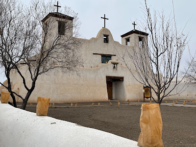
The History of Isleta Mission, New Mexico

By Michelle Shocklee

Growing up in Santa Fe, New Mexico, I visited a lot of missions, old churches, and pueblos through the years. Sometimes with my family; sometimes on school field trips. Sadly, like most kids, I didn't appreciate the things I saw and heard on those long ago visits. Now that I'm old and wise (ha!) I soak up the history of the places I visit. Such is the case of my Christmas pilgrimage to Isleta Mission, 15 miles south of Albuquerque, New Mexico. 

Isleta Mission Church. Photos by Michelle Shocklee

Pilgrimage, you ask?
 
Yep. Let me tell you a little story before I get into the history of the mission. 

My dad's parents were born in Mexico in the 1880s. They were both teenagers when their families immigrated to Texas where they met, married, and started a family. My grandfather attended the Baptist seminary in El Paso and became a Baptist minister. Because vital records in Mexico are hard to locate, I didn't hold out much hope of ever knowing much about my ancestors on Dad's side of the family beyond a few names of my great grandparents. Thankfully I was wrong! When a friend gifted me with an Ancestry .com DNA kit last year, I was wonderfully surprised to discover all sorts of people I was related to through my dad's family, dating all the way back to my 7th great grandmother!

That's where the history of Isleta Mission and my family history converge.

Mission San Agustín de Isleta, founded in 1613, was a Spanish mission in what is now Bernalillo County, New Mexico. It was established by Spanish Catholic Franciscans to spread Christianity among the local Native Americans. If you know anything about New Mexico's history, you know Spanish explorerers "discovered" it in the 1500s. Of course, the Land of Enchantment wasn't lost and in need of discovering. It was already inhabited by various Native American tribes, including Pueblo tribes. Francisco Vásquez de Coronado first saw the Isleta Pueblo around 1540 during his expedition. Later, Franciscan missionaries, who arrived with Spanish colonists in New Mexico beginning in 1598, spread their ministry to Isleta. The church was eventually built and is one of the oldest mission churches in the United States today.

But all was not well. North of Isleta, unrest between the Spanish colonists and the Pueblo tribes continued to escalate. For more than 100 years, the Pueblo people were subjected to the unwelcome presence of soldiers, missionaries, and settlers. These encounters between people of different backgrounds and religious beliefs were characterized by violent confrontations between Spanish colonists and Pueblo peoples, including the horrific massacre of over 800 Acoma Pueblo men, women, and children. 


By 1680, a revolt was planned by the leaders of 46 pueblos, led by a Tewa religious leader named Popé. On August 10, the Spanish people living in the capital city of Santa Fe were shocked when a report came to the governor early in the morning, alerting him that a Spanish priest had been killed at a pueblo only nine miles from Santa Fe. By August 15, 1,000 Spaniards had taken refuge in the Governor's palace in Santa Fe, fearing for their lives. They were soon besieged by an army led by Popé, estimated to number 2,500. On August 21, the Spanish colonists broke out of the Palace and began a long trek south, not stopping until they reached El Paso, Texas. Over 400 Spanish colonists were killed during the revolt, but Pueblo warriors did not attack the departing 2,000 survivors and allowed them to escape.

The people of Isleta Pueblo did not participate in the revolt. Instead, they offered shelter to the Spanish refugees... including my ancestors! While we don't have all the details of what happened to them, I know that my 7th great grandmother was born in Santa Fe in 1664. Her son was born at the Isleta Pueblo in 1683. If we piece together historical facts, we can guess that my family escaped from Santa Fe sometime during the revolt and fled to Isleta. They would have continued their flight to El Paso but later returned when the Spanish once again occupied the mission. 

Today, the massive adobe church of San Agustín still dominates the north side of the plaza of the Pueblo of Isleta. The church is an active parish community, and holds regular services and events. Both Tiwa and English are spoken at the pueblo.

I have no way of knowing if my ancestors participated in the violence against Native Americans. I certainly hope not. But history can't be changed. We can only learn from it and hopefully make the world a better place, where everyone can live in peace. 

Me at Isleta Mission with my DNA results

Your turn! Have you looked into your ancestry? Are there any surprises you'd like to share with us?


Michelle Shocklee
 is the author of several historical novels, including Under the Tulip Tree, a Christy Awards and Selah Awards finalist. Her work has been included in numerous Chicken Soup for the Soul books, magazines, and blogs. Married to her college sweetheart and the mother of two grown sons, she makes her home in Tennessee, not far from the historical sites she writes about. Visit her online at www.MichelleShocklee.com


               COUNT THE NIGHTS BY STARS

*2023 Christianity Today Book Award Winner*

1961. After a longtime resident at Nashville’s historic Maxwell House Hotel suffers a debilitating stroke, Audrey Whitfield is tasked with cleaning out the reclusive woman’s room. There, she discovers an elaborate scrapbook filled with memorabilia from the Tennessee Centennial Exposition. Love notes on the backs of unmailed postcards inside capture Audrey’s imagination with hints of a forbidden romance . . . and troubling revelations about the disappearance of young women at the exposition. Audrey enlists the help of a handsome hotel guest as she tracks down clues and information about the mysterious “Peaches” and her regrets over one fateful day, nearly sixty-five years earlier.
https://www.tyndale.com/p/count-the-nights-by-stars/9781496459930


Thursday, September 8, 2022

El Morro National Monument--where graffiti becomes history

by Martha Hutchens

El Morro National Monument, Martha Hutchens
Those of you who have read my other blog posts may not be surprised to learn that I grew up in southeast Missouri. This heavily agricultural area used to be a swamp. It receives an average of 46 inches of rain per year. The humidity is intense.

Now, imagine moving from that climate to New Mexico. The air is dry, and even today you are wise to take water with you if you are driving through the more rural areas. Now stretch your imagination a little further. What if you are traveling by horse and wagon, or by foot. Water stops that are only an hour or two apart today would be up to a week apart in those conditions.

Pool at El Morro, Martha Hutchens
Then you see El Morro (headland or bluff) standing in the distance, and you know water lies at the foot of it. The pool at the base of this mesa collected water run off from the cliffs around it. Because the pool is in the shade of the cliffs, the water is cool and even more refreshing.

Inscriptions at El Morro, Martha Hutchens
El Morro National Monument has been a stopping point for travelers for centuries, and the soft rock has convinced more than 2000 to leave their mark.

Petroglyphs at El Morro, Martha Hutchens
Ancestral Pueblo people founded a village on top of these cliffs, and their petroglyphs remain behind. It is estimated that as many as 1500 people may have lived in this village, and that the structures had up to 875 rooms. Some structures may have been as high as three stories.

Oñate inscription at El Morro, Martha Hutchens
Juan de Oñate signed the rock in 1605 (15 years before the Pilgrims landed on Plymouth Rock.) He was the first governor of New Mexico under Spain, and is rightly reviled by the Native Americans in the area, for his massacre of the the Acoma people in 1599. He passed El Morro on his way back from what he thought was the Pacific Ocean. In fact, he only got as far as the Gulf of California. It is perhaps a signal of his feelings toward the Native Americans that he wrote his inscription over a pre-existing petroglyph.

Two more Spanish governors signed El Morro in the early 1600’s, Don Juan de Eulate in 1620 and Francisco Manuel de Silva Nieto in 1629. Eulate’s inscription describes himself as a gentleman, but the word was later scratched out. Unfortunately, this editor didn’t sign his name.

In 1632, a Spanish soldier named Luján wrote in stone that he “they passed by . . . to the avenging of the death of Father Letrado,” a priest killed by the Zuni people.

In 1680, the Pueblo people revolted against Spanish rule and the Spaniards retreated from New Mexico. In 1692, General Don Diego de Vargas returned to Santa Fe and reconquered New Mexico, mostly peacefully. He commemorates the event by signing El Morro, where he notes that he has “conquered . . . all of New Mexico at his own expense.” Maybe he thought the Spanish crown should have paid for it?

Several other Spanish inscriptions appear on the rock, with the last dated 1774.

The first American inscription reads, “O. R. March 19, 1836. His simple initials remind us of the many signatures of average people.

In 1848, Mexico ceded New Mexico to the United States as part of the settlement of the Mexican-American War, and in 1850 it was officially organized as a territory. This led to a whole new set of inscriptions on El Morro. Traders, emigrants, soldiers, and others passed by this bluff with its inscriptions and added their own names.

In 1849, Lt. J. H. Simpson and R. H. Kern visited and copied the inscriptions present at that time. Of course, they felt compelled to note their own presence. They carved the following, “Lt. J. H. Simpson & R. H. Kern artist visited and copied these insciptions, September 17 & 18, 1849” After they finished the their writing, they realized they left out the “r” in inscriptions, and inserted it with a editing mark. Talk about your long-lived typos!

Breckinridge inscription at El Morro, Martha Hutchens
One of the more interesting chapters of U.S. Army’s history is their brief experiment with camels as pack animals in the southwest. Four of the men involved in this experiment signed El Morro, E. Pen Long, F. Engle Jr, Byrn, and their leader, P. Gilmer Breckinridge. I assume the camels found the pool at El Morro as refreshing as the humans did.

Udell inscription at El Morro, Martha Hutchens
L. J. Rose led the first wagon train along a new trail crossing New Mexico territory to reach California in 1858. They stopped at the water pool by El Morro, and ten of them signed the wall, including Rose, John Udell, and America Frances Baley, and Sarah Fox, who was only twelve years old at the time. Nearly 500 miles farther along the trail, this train would be attacked by Mojave warriors. Sarah Fox was shot with an arrow and witnessed her father’s death. The caravan’s wagons were burned and the people passed El Morro again on their return to Albuquerque. However, the next year they completed their journey to California along a different trail.

In 1906, Teddy Roosevelt designated El Morro as a national monument, though New Mexico would not become a state for another six years. Since then, much work has been done to protect the inscriptions on the rock, because this soft rock that is so easy to carve also erodes easily. During the depression, Franklin Delano Roosevelt created the Civilian Works Administration, which hired men to make a path to the top of El Morro so that visitors could see the remains of the village that once occupied this area. These 48 men also left their mark on the bluff, though not in writing.

If you visit New Mexico, I highly recommend a stop at El Morro, where a thousand years of history is written in rock.


Martha Hutchens is a transplanted southerner who lives in Los Alamos, NM where she is surrounded by history so unbelievable it can only be true. She won the 2019 Golden Heart for Romance with Religious and Spiritual Elements. A former analytical chemist and retired homeschool mom, Martha is frequently found working on her latest knitting project when she isn’t writing.

Martha’s current novella is set in southeast Missouri during World War II. It is free to her newsletter subscribers. You can subscribe to my newsletter at my website, www.marthahutchens.com

After saving for years, Dot Finley's brother finally paid a down payment for his own land—only to be drafted into World War II. Now it is up to her to ensure that he doesn't lose his dream while fighting for everyone else's. No one is likely to help a sharecropper's family.

Nate Armstrong has all the land he can manage, especially if he wants any time to spend with his four-year-old daughter. Still, he can't stand by and watch the Finley family lose their dream. Especially after he learns that the banker's nephew has arranged to have their loan called.

Necessity forces them to work together. Can love grow along with crops?

Monday, August 8, 2022

Stories from the Secret City (Part 2)--Plus Huge Giveaway


by Martha Hutchens

WAC barracks room, photo by Martha Hutchens
At the end of the last post I told you about a road in Los Alamos named Bathtub Row, because as legend has it, these four houses had the only four bathtubs in town. As I mentioned last time, legends are sometimes wrong, and this one is—at least slightly. Turns out there were at least two more bathtubs in Los Alamos during the war. They were located in the WACs barracks, one of which is still standing today. The picture above is from that building, which is occasionally open for tours. This particular barracks had individual rooms, but many did not.

The women who lived there filled many roles in our town. They manned the PX milkshake machine, filled out numerous army forms, operated the telephone lines, and performed a million other tasks necessary to a town. A select few chosen for their mathematical abilities worked in the tech area as calculators—humans who performed the work that digital calculators do today.

Deposit Photos
As one would expect, some of the most famous scientists of the war figure prominently in the stories of Los Alamos. One legend has George Kistiakowsky, a high explosives expert and avid skier, carefully eyeing the mountains behind Los Alamos and planning his tests. When he finished, he said, “There’s your ski hill.” It is perhaps a bit more accurate—though less colorful--to say that he used high explosives to clear the way to add a rope tow to an existing ski hill.
Niels Bohr on Los Alamos ski Hill
from Just Crazy to Ski
by Deanna Morgan Kirby
Several of the European-born scientists grew up skiing, and that sky hill saw many of them teaching their American colleagues. One famous picture shows Niels Bohr on the local ski hill, though no one will admit to taking the picture. Private cameras were not allowed in Los Alamos during the war years, and photos of the scientists famous enough to travel under pseudonyms--Niels Bohr travelled as Nicholas Baker--were doubly forbidden.

Many Los Alamos legends involve Richard Feynman, who had only recently received his Ph. D. when he arrived in Los Alamos. His irrepressible humor lightens our legends. It is true that Feynman taught himself to crack safes and frequently raided safes of his colleagues in the technical area. It is also true that General Leslie Groves kept candy in his safe. Do we know for sure that the general came into his office one morning to find his entire stash relocated to his desktop, courtesy of Feynman? I suspect it might be. 

Deposit Photos
Feynman gave security fits. One day he discovered a hole in the fence that surrounded the town. I suspect Feynman eyed that fence with a gleam in his eye before he proceeded to exit the town, walk around, and enter through the gate. Legend has it that he did this five or six times before security realized he had entered multiple times, but never left. (In point of fact, there were many holes in the fence. The terrain just didn’t allow for a solid fence. Therefore, the area around the town was also patrolled by mounted MPs.)

While mail coming from overseas was routinely censored, mail from the United States was not. Los Alamos was the exception. All mail leaving the town was censored, which caused Feynman a problem. His wife lived in a tuberculosis sanitarium in Albuquerque, NM. Feynman wrote his letters to her in code, because she loved to break cyphers. Needless to say, the censors were not amused. Eventually a truce was established. Feynman would write his letter in code and include a translation which the censor would read and remove, so as not to deprive Mrs. Feynman of the pleasure of breaking it.

On a side note, Feynman wrote one of the most heart-breaking love letters of all time to his wife after she succumbed to the disease. You can read it here. I find it fitting that even in this somber note his sense of humor emerges at the end, where he writes, “Please excuse my not mailing this—but I don’t know your new address.”

Another group of scientists in Los Alamos were called the Special Engineer Detachment. Many of these young men had joined up after Pearl Harbor and had technical degrees so they were assigned to the Manhattan Project. One young man got assigned to New Mexico after helping clear a lab in the Pacific. Looting was entirely forbidden, but this soldier spied an platinum beaker and slipped it in his pocket. Not long after he received new orders, but due to the secrecy they didn’t tell him where he was going, only that MPs were going to accompany him. He spent the entire trip convinced he was being sent to Fort Leavenworth for taking that platinum beaker.

The legends of Los Alamos are many and varied. I hope you have enjoyed the ones I have shared with you.

Martha Hutchens is a transplanted southerner who lives in Los Alamos, NM where she is surrounded by history so unbelievable it can only be true. She won the 2019 Golden Heart for Romance with Religious and Spiritual Elements. A former analytical chemist and retired homeschool mom, Martha is frequently found working on her latest knitting project when she isn’t writing.

Martha’s current novella is set in southeast Missouri during World War II. It is free to her newsletter subscribers. You can subscribe to my newsletter at my website, www.marthahutchens.com

After saving for years, Dot Finley's brother finally paid a down payment for his own land—only to be drafted into World War II. Now it is up to her to ensure that he doesn't lose his dream while fighting for everyone else's. No one is likely to help a sharecropper's family.

Nate Armstrong has all the land he can manage, especially if he wants any time to spend with his four-year-old daughter. Still, he can't stand by and watch the Finley family lose their dream. Especially after he learns that the banker's nephew has arranged to have their loan called.

Necessity forces them to work together. Can love grow along with crops?

Giveaway Info:

To celebrate reaching 3 Million views, HHH is hosting a HUGE giveaway of over 60 books in 18 prizes, so there are many chances to win! One grand prize will consist of 10 books, two readers will win a second prize containing 5 books, and there will be 15 winners of a third prize containing 2 books each. There are several ways to earn entries, such as following, or commenting on the HHH blog each day. Thank you for being part of the HHH community, and best wishes in the giveaway!

http://www.rafflecopter.com/rafl/display/ce16d9c612/?

Monday, November 9, 2020

Four States, Four Tribes, Four Corners

By Tiffany Amber Stockton


Last month, I shared about the world's largest natural hot spring existing right here in Colorado. If you missed that post, you can read it here: https://www.hhhistory.com/2020/10/largest-natural-hot-spring-in-world.html.

Today, we're taking a little trip away from that hot spring to the far southwest corner of Colorado. 

THE POWER OF FOUR


Have you ever stood in one place and touched 3 different states? There are a lot of chances across the US to do that, and less than a handful of states which only touch 2 other states. But how about standing in one place and touching FOUR different states? An intersection. And that place is called the Four Corners Monument.

Mesa Verde Cliff Dwellings
Last summer, a friend of mine came to visit, and we traveled to the southwest corner of Colorado, Durango to be specific. As part of that weekend blitz, we went a little further southwest and took in the Mesa Verde Cliff Dwellings. When I looked at a map of the area and realized we were only 30 miles from Four Corners--a place I had wanted to visit since childhood--I knew we had to go. It would mean not getting home until midnight or later at the end of our weekend, but we had to do it!

Monument in 1962
The Four Corners area is named after the point where the boundaries of four states (Utah, Colorado, Arizona, New Mexico--just think UCAN) meet, where the Four Corners Monument is located. It is the only location in the United States where four states meet. Most of the Four Corners region belongs to semi-autonomous Native American nations, the largest of which is the Navajo Nation, followed by Hopi, Ute, and Zuni tribal reserves and nations. It's mostly rural, rugged, and arid. In fact, while driving, it reminded me a lot of a desert. Not a desert like the Sahara with nothing but sand, but a mountainous desert with rock formations combined with sand.

Monument in 1992
The United States acquired the four corners region from Mexico after the end of the Mexican–American War in 1848. In 1863 Congress created Arizona Territory from the western part of New Mexico Territory. The boundary was defined as a line running due south from the southwest corner of Colorado Territory, which had been created in 1861. This was an unusual act of Congress, which almost always defined the boundaries of new territories as lines of latitude or longitude, or following rivers. By defining one boundary as starting at the corner of another, Congress ensured the eventual creation of four states meeting at a point.

Monument in 1989
When I researched photos of this monument, I was surprised to see it once sat in the middle of what seemed to be "nowhere" with nothing but open space around it. Over the past 150 years, this site has seen a lot of changes.

My feet touching 4 states
By 1899, the sandstone shaft marker placed by Chandler Robbins in 1875 had been disturbed and broken, so it was replaced with a new stone by two U.S. Surveyors, Hubert D. Page and James M. Lentz. In 1912, a simple cement pad was poured around the marker. The first modern Navajo government convened in 1923 in an effort to organize and regulate an increasing amount of oil exploration activities on Navajo lands, and they played a big role in the monument's further development.

Monument in 2013
In 1931, Everett H. Kimmell, another U.S. Surveyor, found this newer stone had broken too and he replaced it with a brass disc marker set in cement. In 1962, the Bureau of Land Management and the Bureau of Indian Affairs poured an elevated cement pad around the 1931 brass marker; this pad included the state border lines and names in tile. The monument was completely rebuilt in 1992, and the 1931 brass marker was replaced with a disc shaped aluminum-bronze plate set in granite. The monument was again rebuilt in 2010, although the disc shaped plate from 1992 remained in place.

Monument showing Navajo and Ute
selling booths at the perimeter
The monument I and my friend visited with the individual stone booths where the various Navajo and Ute Indians sell their hand-made items is obviously a lot newer than I at first thought. Prior to 2010, it seems those booths and walls weren't there at all. Completely changes the landscape and appearance. It doesn't diminish the experience of touching four states at once, though. :) And I loved being able to shop genuine Navajo items without the middle man jacking up the price. This way, I knew my money was going straight to the craftsman or designer, and it was a lot of fun chatting with them.

Finally, just for fun, here's an animated GIF image showing the progression of the 4 states from territories into the states we have today.

Now it's YOUR turn:

* Have you ever been to Four Corners? When did you go?
* Where else in the U.S. have you visited that is designated as a national monument or a national park? And what was your favorite part about your visit? 
* What is your overall favorite national park or monument to visit?


BIO

Tiffany Amber Stockton has been crafting and embellishing stories since childhood, when she was accused of having a very active imagination and cited with talking entirely too much. Today, she has honed those childhood skills to become an award-winning and best-selling author and speaker who is also an advocate for literacy as an educational consultant with Usborne Books. She loves to share life-changing products and ideas with others to help better their lives.

She lives with her husband and fellow author, Stuart Vaughn Stockton, along with their two children and two dogs in Colorado. She has sold twenty (24) books so far and is represented by Tamela Hancock Murray of the Steve Laube Agency. You can find her on Facebook and GoodReads.

Wednesday, October 28, 2020

History of the Harvey Girls by Donna Schlachter


Outside a typical Harvey House c.1900
 
While Fred Harvey and his company changed how folks traveled the west from 1876 until the mid-1950s, perhaps the thing most folks recall are the waitresses in his restaurants, who came to be known as The Harvey Girls.

Dining cars were implemented in the 1880s, but food was expensive, and most passengers opted to purchase their meals at the train depots, which usually provided only sandwiches and coffee. Mr. Harvey felt there had to be a better way.


After building a string of hotels along the rail lines to serve for passengers who
were stopping over, he soon added dining rooms with full service guaranteed in half an hour.

Originally, Mr. Harvey hired only men to serve the meals, but in 1883, he had to fire his entire staff at one of his houses in New Mexico. His manager recommended he hire women because they were less likely to get into drunken brawls.

However, a ready supply of young, reputable women was in short supply west of the Mississippi, so he advertised in the east for women willing to train in Kansas City then travel west to their new home for at least the next six months.

Each Harvey Girl signed a contract and affirmed she wouldn’t date other employees, would observe the dress and conduct codes, would wear and maintain her uniform, and would generally do as she was told. In exchange, she received room and board, was introduced to a better class of patrons, and was paid an above-average salary while living in a part of the country she’d unlikely have had the opportunity to ever see otherwise.


The classic Harvey Girl uniform c. 1900
 
At first, the concept of a woman working outside the house engendered criticism, mostly because of past experience with employers and situations of low repute, including saloons and brothels. Mr. Harvey countered this disapproval by using stark uniforms reminiscent of a nun’s habit, forbidding makeup, enforcing curfews, and hiring women with good references.

The Harvey Girls worked six or seven days a week, often twelve or more hours a day, serving meals to train passengers. Food orders were telegraphed ahead so meals were ready when the train pulled in, since the stopover was most often only thirty minutes. In those days, other restaurants and dining rooms served bad food at exorbitant prices, so the Harvey House standards were much appreciated.

In fact, Mr. Harvey insisted that his chefs be professionally trained, and he limited the number of dishes available to customers to streamline both the ordering and the preparation of the meals.

Many young women replied to his ads, and records indicate that more than 100,000 women worked for him over the eighty years of business until the private automobile spelled the decline in train travel.


Harvey Girls taking a sun break c. 1900


Perhaps one of the most endearing facts about the Harvey House and its “Girls” is that many of them started working for Mr. Harvey in hopes of meeting a rich passenger from a train who would marry them and take them elsewhere. However, most ended up renewing their contracts many times. And even when their contract was done, more than half of the women stayed in the area, married and having families, helping to settle the Wild West. One of the longest-serving Harvey Girls worked for the company in excess of 40 years.


Resources:

https://truewestmagazine.com/harvey-girls/

https://cowgirlmagazine.com/wild-women-of-the-west-the-harvey-girls/


About Donna:

Donna writes historical suspense under her own name, and contemporary suspense under her alter ego of Leeann Betts, and has been published more than 30 times in novellas, full-length novels, and non-fiction books. She is a member of ACFW, Writers on the Rock, SinC, Pikes Peak Writers, and CAN; facilitates a critique group; teaches writing classes; ghostwrites; edits; and judges in writing contests. www.HiStoryThruTheAges.com


Friday, August 7, 2020

The Battle of Glorieta Pass, New Mexico

By Michelle Shocklee

When I was a kid growing up in Santa Fe, New Mexico, the American Civil War wasn't something I was interested in. I mean, it all took place back east a gazillion years ago, right?

Wrong.

Winding mountain road alongside the Pecos River. I've
traveled this road hundreds of times! Photo on Google
Turns out I lived 22 miles from a bonafide Civil War battlefield. Every time my family drove into the Pecos National Forest for a day of picnicking or camping, we passed through said battlefield. It isn't a well known battle, but the outcome may have played a huge role in the outcome of the entire war.

First, a little history.

In March 1862, New Mexico wasn't a state, it was a territory. The lower half of it as well as present-day Arizona had fallen under Confederate control and was called the Confederate Arizona Territory. The territorial capital was Mesilla, near what is now the city of Las Cruces, NM (where I went to college my freshman year!). Why would the Confederacy--and the Union Army, for that matter--want to occupy land so far away from the battles taking place back east?

The answer can be summed up in a couple of shiny words: Gold and silver. Silver and gold. (Cue a cute singing snowman!)

Apache Canyon, scene of the first phase of the Battle of Glorieta Pass; 
Photo on Google
California and Colorado were both gold and silver producing states. Whoever had control of these states and the trade routes in/out of them would have a huge advantage over the opponent. New Mexico sat right in the middle of it all. Both sides knew this and were doing everything possible to gain and keep control of the territory.


By August 1861, Union troops stationed at Fort Craig (in southern NM) had already suffered defeat by the Confederate 2nd Texas Mounted Rifles as well as another defeat nearby in September at the Battle of Canada Alamosa. This gave the Confederate generals confidence to move forward with a bold plan.


"Sharpshooters ridge" above Pigeon's Ranch where Union troops
hunkered down at one point; Photo on Google
In the cold days of early 1862, Confederate General Sibley was determined to march his army north to capture the capital city of Santa Fe. Once Santa Fe was in Confederate control, they would turn their attention towards capturing the stores of ammunition and food at Fort Union (north of Santa Fe), gain control of the Santa Fe Trail, then turn west toward the gold fields of California. Success was his in February when his army defeated Union troops in the Battle of Valverde, although both sides suffered losses. Sibley continued his northern march and took possession of Albuquerque on March 2 and Santa Fe on March 13. Supplies and ammunition, however, were running dangerously low. Although a supply wagon train was on its way to them, Sibley hoped to capture Fort Union--a fort he'd been personally acquainted with prior to the war--to replenish.

Meanwhile, the First Regiment of Colorado Volunteers marched rapidly down from Denver to reinforce the Union troops at Fort Union. Confederate scouts were captured on March 25, providing invaluable information regarding the location of Sibley's army at the far end of Glorieta Pass preparing to march north the next morning.

Burning of Confederate supply wagons

Unaware that the Colorado troops were in New Mexico, Sibley anticipated little trouble. Mistake. On March 26 and 28, the two armies clashed. Fighting took place among the craggy rocks and evergreen trees, which prevented both sides from using their cavalry. The turn for a Union victory came when the Confederate supply wagon train was captured and destroyed, including, sadly, all of the animals. Without the much needed resources, there was no way for Sibley's men to continue the fight. A flag of truce was offered by Confederate Colonel Slough and was accepted by Union Colonel Slurry.


March 29 was spent burying the dead. The Texans were forced to retreat to Santa Fe and eventually took a long, dangerous march back to Texas. By July 1862, all Confederate Troops had vacated New Mexico Territory and for the duration of the Civil War, New Mexico remained under Union control. It is said that had the Confederates taken control of the gold and silver produced in the West, they would have won the war. What a different country it would be today if that had happened.

A monument at the center of Santa Fe honors the men who fought and died in the various Civil War battles in New Mexico Territory, including Valverde and Glorieta Pass.

Glorieta Pass monument in the center of the famed Santa Fe Plaza
Photo on Google

Your turn: Have you been to Santa Fe? Did you know about New Mexico's role in the Civil War?


Michelle Shocklee is the author of several historical novels. Her work has been included in numerous Chicken Soup for the Soul books, magazines, and blogs. Married to her college sweetheart and the mother of two grown sons, she makes her home in Tennessee, not far from the historical sites she writes about. Visit her online at michelleshocklee.com.


UNDER THE TULIP TREE
Releases September 8, 2020

Sixteen-year-old Lorena Leland’s dreams of a rich and fulfilling life as a writer are dashed when the stock market crashes in 1929. Seven years into the Great Depression, Rena’s banker father has retreated into the bottle, her sister is married to a lazy charlatan and gambler, and Rena is an unemployed newspaper reporter. Eager for any writing job, Rena accepts a position interviewing former slaves for the Federal Writers’ Project. There, she meets Frankie Washington, a 101-year-old woman whose honest yet tragic past captivates Rena.

As Frankie recounts her life as a slave, Rena is horrified to learn of all the older woman has endured—especially because Rena’s ancestors owned slaves. While Frankie’s story challenges Rena’s preconceptions about slavery, it also connects the two women whose lives are otherwise separated by age, race, and circumstances. But will this bond of respect, admiration, and friendship be broken by a revelation neither woman sees coming?