Showing posts with label weather. Show all posts

Saturday, June 11, 2022

When Sky and the Earth Wreak Havoc

Worst Natural Disasters in History 

by Martha Rogers


I've been through many storms from hurricanes to tornadoes to floods, and they have always fascinated me and had me thinking about the results left behind. Our country has seen many natural disasters caused by what insurers call "An Act of God."

When a weather pattern forms circles with a low-pressure center, whether rotating clockwise or counterclockwise, it is technically known as a cyclone. This includes hurricanes and tornadoes as well as larger systems such as a middle-latitude cyclones. Hurricanes and typhoons are two names for the same type of storm--a strong tropical cyclone. The names are interchanged in various areas of the world. Today, we look at some of the greatest ones in history before 1950.

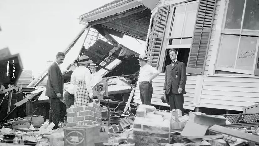
Several years ago I did an entire blog on the Galveston hurricane that devastated the island and caused hundreds of death. It happened before hurricanes had names and is simply known as the Galveston Hurricane of 1900. It hit shore and became the deadliest storm to hit on American soil in history with 140 MPH winds and fifteen foot waves. Estimates of deaths ranged between 8,000 and 10,000 people killed. Even a year later, bodies were found washed ashore. 


Since then, hurricanes have hit the Gulf and Atlantic coast lines from deep South Texas to both coasts of Florida and up the Atlantic coast on up to Canada. Meteorologists refer to hurricanes as the most deadly storms to hit land. Because of the length of time they take to move through an area and how long they can last, death tolls and destruction runs high.

Most of us remember the more recent ones from Carla, to Camille, to Katrina, Rita, Ike, Sandy, Andrew to name a few. The damage from a hurricane can be as devastating today as it was over a one hundred years ago. Now, the National Weather Service can be much more accurate in their predictions of where the storms will make landfall, how large they are and how fast the winds are.

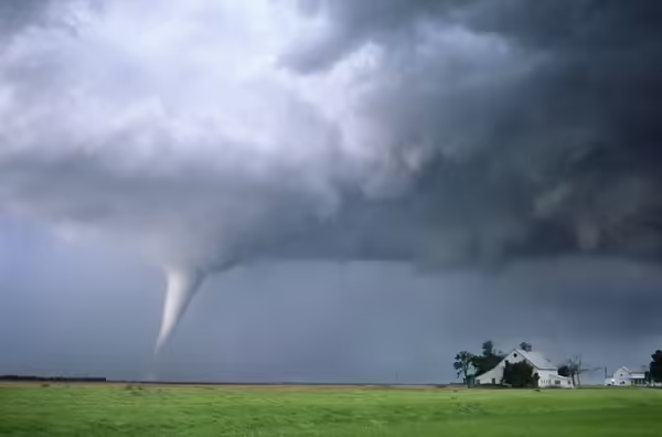
Most of remember the tornado featured in The Wizard of Oz. That fictional storm took place in Kansas. In reality, Kansas, Missouri, Oklahoma and other mid-west plains states are in the heart of tornado country and what has been called "Tornado Alley." 


Of all the destructive power of storms, none have the ferocity and form of tornadoes. They come down like a sword from the sky and lash out at their surroundings as though with malicious and mindful intent to destroy. These columns can reach speeds of over 300 mph and measure from a mile to many miles across. They scar the earth and destroy homes and buildings in brief moments of twisting and turning in their fury. 

They year 1925 saw such a storm rage across the mid-west bringing destruction to towns across three states from Missouri to Illinois and into Indiana. The


distance was 219 miles and the tornado traveled it in about three and half hours. Because of the straight path for 183 miles, scientists believe it might have been a family of tornados spawned by a massive supercell storm. It is one of the deadliest and most destructive tornadoes to hit the mid-west states.

In March of1888, a hurricane on the Atlantic coast came ashore as a blizzard that devastated states along the upper coast. Known as the Great White Hurricane, it immobilized cities such as New York with the amount of snow that fell. It paralyzed the East Coast from the Chesapeake Bay to Maine and on up to the Canadian Atlantic coast cities.


Brooklyn, New York in March, 1888

The snow piled high in the streets and kept people indoors for several days. Damage to spring crops like the apple trees in Connecticut ran high, and loss of life. Property damage ran to more than $20 million and 400 lives were lost, include 100 sailors across the east coast. 

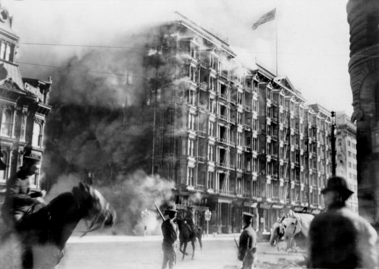
Other natural disasters which took hundreds of lives and caused millions in property damage include the great earthquake in San Francisco. 
This massive earthquake occurred the morning of April 8, 1906 and took the lives of 3,4400 people and destroyed close to 80% of the city. The quake lasted only a minute, but firefighters spent four days putting out fires. Thousands were left homeless and lived in tents.

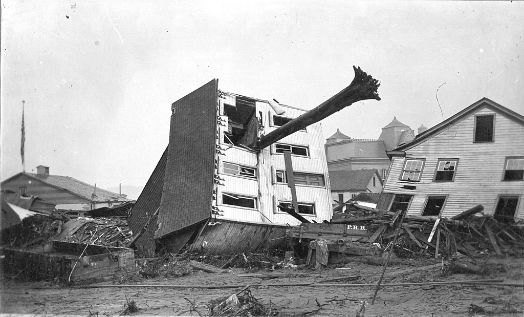
The Johnstown Flood is also listed with the top natural disasters and was the first one attended to by the American Red Cross. It became crucial in the history of natural disasters because of the lack of disaster and crisis management. A combination of heavy rain and a dam break sent 20 million gallons of water into the Mississippi River. This surge of water created a 70 foot high wave of water that traveled over fourteen miles on May 31, 1889. It destroyed everything and everyone in its path.

This is the John Schultz home in Johnstown. As it floated away down the street, a tree skewered it. Miraculously, the six people inside the home survived.

Tsunamis, volcano eruptions, typhoons are other acts of nature that wreak havoc over the land and sea. We can be thankful today for the Natural Weather Service which can warn us of such storms and disasters and allow us to find shelter and safety.

I have featured storms in several of my books. The Great White Blizzard is featured in my book Summer Dream. Have you ever been through a strorm that left behind destruction and/or death? Comment below and leave your email address for a chance at a free copy of this book.

Rachel Winston is the daughter of a minister in Briar Ridge, Connecticut. 
When a friend of her best friend's brother comes to visit, Rachel is attracted to him, but Nathan Reed wants nothing to do with a Christian, much less the daughter of a minister because of tragedy in his own family that caused him to turn from God.

After he is caught in a blizzard and nearly dies, the ministries of Rachel and her mother show him the true meaning of God's love. Now he must make amends with his family for his past and pray that Rachel will wait for him.


Martha Rogers is a multi-published author and writes a weekly devotional for ACFW. Martha and her husband Rex live in Houston, Texas where they are active members of First Baptist Church. They are the parents of three sons and grandparents to eleven grandchildren and great-grandparents to six. Martha is a retired teacher with twenty-eight years teaching Home Economics and English at the secondary level and eight years teaching Freshman English at the college level. She is a member of ACFW, ACFW WOTS chapter in Houston, and serves as President of the writers’ group, Inspirational Writers Alive.  


Monday, February 4, 2019

Horses Wearing Snowshoes

by Anita Mae Draper

Woodcut from Historia Delle Genti, by Olaus Magnus, 1565 edition. Library of Congress 

While researching my Lapp & Finn heritage, I happened upon the above image of a woodcut from a book published in 1565 about the history of northern people. Intrigued, I soon discovered that North Americans also put snowshoes, and even mudshoes, on their horses when needed to distribute their weight over a larger area to keep them from sinking into the snow or mud.

In 1888, James Mason Hutchings wrote In the Heart of the Sierras, a comprehensive work of natural and human history of Yosemite. On the topic of traveling through snow, he experimented with wooden snowshoes on horses and came to a successful conclusion which he describes in his book in detail, including this next illustration which shows the underside of the wooden snowshoe.


In the Heart of the Sierras by James M. Hutchings (1888). Public Domain

Concerning the snowshoes, Hutchings wrote that, "...Each animal seems to have an intuitive knowledge of what they are for, as of the duties expected of them; for, carefully lifting the foot higher than he would under normal circumstances, with a somewhat rotary and semi-oscillary movement, he throws his foot forward, and one shoe over the other, with such intelligent dexterity that they rarely touch each other...There is no confusion or even awkwardness in their use, although there is in appearances when seeing horses in such ungainly-looking appendages."

Similar horse snowshoes were used in the British Columbia goldfields as shown in this next image from the book, Prospectors, Promoters and Hard Rock Miners by Ian McLeod (with Holly McNeil). 


Bill Stewart with a horse on wooden snowshoes in Stewart, B.C.; Courtesy of Stewart Historical Society Museum

In 1891, Edward James Glave led an unoffical exploration from Seattle to Alaska with the purpose of finding a transportation route with adequate forage for horses. Such a route would enable Alaska to receive food and goods as well as send furs and gold south without depending on water routes. Instead of staying close to shore, Glave headed inland and then north, following the valleys where his animals had no problem finding nourishment. Glave's horses had been trained to walk the narrow paths on mountainsides when they needed to find a pass through, but when he encountered deep snow, he taught them how to walk on snowshoes...human snowshoes...


In the article, Alaskan Exploration in 1891 by John Bonner, published in The Californian Illustrated Magazine Oct 1891 to May 1892, Glave said, "They were the ordinary Canadian snowshoes, oval in shape, and rather small. At first the horses were awkward with them; but after a time they learned the trick of spreading their feet apart, and seemed to understand the purpose of the unusual hoof gear."

Around 1881, Edward Whymper engraved a winter scene showing a horse with a different type of snowshoe pulling a cutter in Eastern Canada. More open than the solid wood type, these round snowshoes were crafted of wood, metal and leather, based more on the traditional look than the wooden type.


Horse in Snowshoes, Pulling Cutter, Eastern Canada, ca.1881; Courtesy of Glenbow Archives

A close-up of the above snowshoe style is on display online through the digital website, of the Norsk Folkemuseum (Norwegian Museum of Cultural History) where they are called hestetruger (horse snowshoe). 


Similar to the underside of the solid wooden snowshoes, the metal chains and leather straps help to keep the snowshoes from slipping on ice and snow. Here's an image from the McCord Museum in Montreal that shows the underside of the snowshoe as a man puts one on the horse.


Putting Snowshoes on Horse, about 1900; Courtesy of the McCord Museum

Although this next image looks like a line of mounted antique baby shoes, what you're looking at are ca.1900 horse snowshoes displayed at the Canadian Museum of History. This type of horse snowshoe isn't as common as the others, probably due to the expense of crafting the leather "boots". I wonder if they were made for a particular horse, or could they be adjusted to fit different sizes?


Horse snowshoes, circa 1900. Canadian Museum of History

The history timeline of Bradford, Ontario, Canada, states that in 1872, "Bradford prospered with businesses such as lumber and mattress making using Marsh hay. Horses used in the harvesting of the hay used wooden snowshoes like clogs strapped to their front feet to prevent them from sinking into the marsh."

Using the Library of Congress Chronicling America website, I found numerous newspaper articles that mention snowshoes on horses including these topics:
- Idaho County Free Press (Grangeville, Idaho), January 2, 1902 (Horses on Snowshoes common in the Buffalo Hump District)
- Mountain Home Republican (Mountain Home, Idaho) April 8, 1922 (Horse on snowshoes to take the mail and supplies through)
- The Owyhee Nugget (Silver City, Idaho) December 7, 1911 (The shoes the horse wears are round, similar in construction to those worn by men)
- Wood River Times (Hailey, Idaho) April 11, 1887 (If the breaking team were provided with horse snowshoes, such as have been used in the mountains of California)

Although the above newspapers are from Idaho, you can see that snowshoes were used in other mountain regions when the path became treacherous due to the weather. They weren't only used in the west, either. I've mentioned that they were used in Eastern Canada, but did you know they were used in New England as well? Check out the article, Collector's Antique Tools, Gadgets in Good Hands, about the Sheffield Historical Society in Sheffield, Massachusetts, and how it's preserving the past, including a photo of the actual size of a wooden horse snowshoe. 

Did you know that horses wore snowshoes? What do you think? 


~~~~~~~~~~~~~~~~~~~~~


Anita Mae Draper is a veteran of the Canadian Armed Forces who served twenty years on Air bases with her eyes on the skies. She uses her experience and love of history to pepper her stories of yesteryear's romance with hardship, faith, and joy. Anita Mae Draper's published stories appear in Barbour Publishing, WhiteFire Publishing, and Guideposts Books. Readers can enrich their story experience with visual references by checking out Anita's Pinterest boards. All links available on her website at www.anitamaedraper.com


Friday, September 14, 2018

Minnesota: A Land of Extremes

Gabrielle Here:

One of my favorite exhibits at the Minnesota Historical Society is called Weather Permitting. It focuses on the extreme weather we experience in Minnesota, and even has a simulated tornado, which you learn about while sitting in a basement. From tornadoes to blizzards to record-breaking temperatures, we see it all here in the Land of 10,000 Lakes.

For almost two centuries, since 1819, the state has kept nearly continuous meteorological records. I thought it would be fun to share some of the extreme records in Minnesota weather over the past 130 years! You may be surprised.

Minneapolis, Minnesota Weather Station - 1890
Minnesota Extremes:

Highest Temperature was July 29, 1917 (and July 6, 1936) at 117 °F.

Highest heat index was July 19, 2011 at 130 °F degrees.

Lowest Temperature was Feb. 1996 (I remember!) at -60 °F

Lowest Wind Chill was January 9th, 1982 at -71 °F.

Largest single-day change was a 71 °F drop on April 3, 1982.

Most snow in one snowstorm was Jan. 6-8th, 1994 with 47 inches.

Earliest recorded snow was on August 31, 1949

Latest recorded snow was on June 4, 1935

In 2010 we broke many state-wide records for the number of tornadoes in one day (48), in one month (71) and in one year (113). That summer (the year my twins were born) I had to bring my children down into our basement six times, which surprised me, because in the eight years we lived in that house, I had never had to bring them down there before.

I didn't mention the record rain, hail, flooding or droughts we've had. More proof that you never know what to expect in the Land of 10,000 Lakes. Needless to say, Minnesota is a state of extreme weather. It's one of the reasons we live here (I think).

What about you? Do you have extreme weather where you live? Have you ever had to take shelter in a basement for a tornado? Ever weathered a blizzard? Had school canceled because of cold weather?

Gabrielle Meyer lives in central Minnesota on the banks of the Mississippi River with her husband and four children. As an employee of the Minnesota Historical Society, she fell in love with the rich history of her state and enjoys writing fictional stories inspired by real people and events.

Find her on Facebook
Find her on Pinterest
Find her on Twitter
Find her on Amazon
Find her on Goodreads
Find her on Her Website
Sign up for Her Newsletter

Thursday, February 5, 2015

The 1912 Niagara Falls Ice Bridge


Last year while working on genealogy research in Southern Ontario I came across a newspaper story about the 1912 collapse of the Niagara Falls Ice Bridge. It wasn't so much the collapse that intrigued me, but that people were allowed to walk across the frozen river while water was still flowing over the Falls. How dangerous and silly that sounded. Did I understand the facts correctly?

As usual - because I'm a visual person - my research began by looking for images. I quickly found out that two historical events came up under this topic... the 1938 collapse of the Fallsview Upper Steel Arch Bridge... and the 1912 collapse of the natural Ice Bridge, the latter of which is what we're focusing on today.

One of the first images I discovered was this 1910 postcard entitled, Ice Bridge, Niagara Falls, published by the S.H. Knox & Co, printed in Germany.


Ice Bridge, Niagara Falls, 1910, published by the S.H. Knox & Co, printed in Germany. Courtesy of the Baldwin Room of the Toronto Public Library Digital Archives.

It was a nice postcard, but it didn't look real - more like a ski chalet environment, especially with all those people around. Was the image date accurate, or merely the printing date?

Over on the McCord Museum site, I was very surprised to find an actual image from 40 years prior to the above postcard. And even more surprised to see that it was more real than even I imagined for not only did it confirm the image on the postcard, it showed a row of buildings, people sliding down the side of the cliff, and what looks like mist/fog from the flowing falls.


Photograph | American Falls from Ice Bridge, Niagara Falls, NY-ON, about 1870 | MP-0000.1452.186
American Falls from Ice Bridge, Niagara Falls, NY-ON, about 1870. Courtesy of  the © McCord Museum Digital Archives.

I focused my research on the tunnel-like structure on the left side of the images and discovered a reference to the Ferry Stairs in Orr's 1842 Pictorical Guide to the Falls of Niagara: 


Entrance to the Ferry Stairs, Orr's 1842 Pictorial Guide to the Falls of Niagara. Courtesy of GoogleBooks.

John William Orr created his guidebook to be read as if a guide was leading you around. Here's what he wrote about the Ferry Stairs: "...proceed to the Ferry Stairs, descend, take a view of the American Falls from its foot, pass behind the sheet, if you like, and then cross the river."

The ferry which Orr speaks of began in 1846 as a regular ferry to transport people and goods across the Niagara river, but has evolved into the famous Maid of the Mist boat tours with landings on both the American and Canadian sides.

Originally built in 1818, the Ferry Stairs were replaced in 1846 with an incline railway - 2 open cars holding about 15-20 passengers each - going in a different direction at the same time. But in 1907, the cable broke and both cars crashed into the chalet at the base of the incline, killing one person and injuring four others. Instead of repairing the incline railway, they began work in 1908 on an elevator system to reach the top-side Prospect Point. We can surmise then, that all images showing the tunnel-like structure with a chalet at the bottom pre-date July 1907. 

So what of the people and the carnival-like atmosphere on the ice? Unfortunately, that part is true. But before I get into that, I want to show you the area in question. Here's a recent GoogleEarth image of the complete American/Bridal Vail/Horseshoe Falls area with the yellow outline showing the narrowest part of the river which is where the ice bridge forms. The red circle shows the location of the first 2 images in this post, although there is now the elevator and observation tower close to where the stairs and incline railway used to be. 


Niagara Falls, 2014. Courtesy of Google Earth

When the wind blew huge chunks of ice from Lake Erie down the Niagara River and over the falls, the chunks would pile up at the narrow part of the river between the two ferry landings, forming an ice bridge. 

With Niagara Falls already being a tourist destination, local businesses took advantage of the public's eagerness to experience the ice bridge and shanties popped up along the route which provided refreshments, such as hot drinks, liquor, and wienerwurst. Photographers set up stalls for once-in-a-lifetime photo opportunities. And the very bravest could have the supreme boasting privilege of renting a shanty and staying the night. Or should that be the most fool-hardy? I'll let you decide.

This next photograph taken from the Canadian side - probably from the middle of the cantilever bridge - shows the proximity of the shanties to the bombarding water. 


Ice bridge from the Canadian side - Niagara Falls in Winter, ca 1890. Courtesy of the Niagara Falls (Ontario) Public Library

A road to the ferry landing on the Canadian side enabled horses for riding and pulling sleighs to make their way down to the bottom and journey across the frozen snow pack. In one photo, I even saw a woman pushing what looked like a baby's pram, except the quality was too poor to show here. 


Horse and Sleigh rides were available to cross the Ice Bridge in the Niagara River, ca 1890. Courtesy of the Niagara Falls (Ontario) Public Library

This next photo is undated and it's not clear whether these two women left the path and went exploring, or took a chance when others didn't. Regardless, you can see the mist from the American Falls in the background. 


Ice Bridge Niagara / Niagara Falls in Winter, undated. Courtesy of the Niagara Falls (Ontario) Public Library

Take a good look at this next photo as it was taken just minutes before disaster struck at noon on Feb 4, 1912. On the left is the Maid of the Mist boat launch building which leads to the Prospect Point elevator. You also see refreshment booths along the path to the Canadian side. According to the records, approx 35 people were on the ice bridge at the time.


Frozen Niagara River with American Falls in the background just before the fatal disaster of February 4, 1912. Courtesy of the Niagara Falls (Ontario) Public Library

According to the website, Niagara Falls Info, "William "Red" Hill was opening the little refreshment stand he built every year as soon as the ice was thick enough…Hill suddenly felt a small tremor under his feet. At that same moment came a loud groaning sound from the base of the Falls which made the roar of the distant Falls faint. Immediately Hill recognized the danger and began running towards the Canadian shore as he shouted for the others to follow him..." 

And from The Toronto World, we find this...


At the top level Observation Deck of the Hornblower Plaza in Niagara Falls, Ontario, the Burrell Hecock Memorial plaque is set into a stone wall. It reads: "To the memory of Burrell Hecock of Cleveland Ohio aged 17 years who lost his life in an heroic attempt to rescue Mr. and Mrs. Eldridge Stanton of Toronto Ontario when the ice bridge in the gorge immediately below was swept down the Niagara River and into the Whirlpool Rapids, February 4th, 1912".


Burrell Hecock last seen in this photo, stranded on an Ice Floe in the Niagara River after attempting to rescue others.  Courtesy of the Niagara Falls (Ontario) Public Library

Several rescue attempts from the two bridges above were aimed at Eldridge and Clara Stanton without success until finally, Niagara Falls Info states, "Stanton took his wife in his arms, kissed her and let her down. They both knelt together with his arms around her. The remaining piece of the ice bridge remained intact until it reached a giant wave in the rapids. It spilled over throwing both of them into the raging water to their deaths."

Niagara Falls attracts twelve million tourists annually and the ice bridge continues to form, but since 1912, the frozen river isn't the winter playground it used to be, and no one is allowed to use it as a route across. 

It doesn't mean they don't try...just that they shouldn't. But that's another story...


So...adventure or folly? Would you try it?

~~~~~~~~~~~~~~~~~~~~~~~


Anita Mae Draper is retired from the Canadian Armed Forces and lives on the prairie of southeast Saskatchewan, Canada with her hubby of 30 plus years and the youngest of their four kids. Anita's historical stories are set in the western prairies and Ontario. She is blessed to be included in Guideposts Books A Cup of Christmas Cheer collection. Anita is represented by Mary Keeley of Books & Such Literary Management. You can find Anita Mae at  www.anitamaedraper.com

Monday, January 5, 2015

Trains on Ice

by Anita Mae Draper


Some of you may be familiar with ice roads from watching tv shows like the History channel's reality series, Ice Road Truckers. Ice roads have been used for years as an efficient method of travel where ice freezes to a deep thickness from December to March or April.


Photographie | Transport du foin au marché de l'autre côté du fleuve Saint-Laurent, QC, 1903 | VIEW-3618
Transportation hay to market across the St. Lawrence River, QC, 1903. Courtesy of McCord Museum VIEW-3618


And along with vehicle roads on ice, there were ice bridges for trains, often called ice railways. Now trains are heavy when compared to early cars or horses and hay wagons, and even much heavier than the 18-wheel trucks you see on Ice Road Truckers which means you need very thick ice to support the weight. Extremely thick ice.

Back in the early 1980's when I was a member of the Canadian Armed Forces and on exercise in Yellowknife in Canada's Northwest Territories, I got my first look at an ice road. It seemed to be nothing more than a line slaking across the North Arm of Great Slave Lake as shown in this photo I took on that cold March day.


Now imagine a heavy locomotive travelling on that stretch. Scary, isn't it? Why did railway owners take the chance with their freight and human lives to travel across ice? Time, money, practicality.

Before the railway bridge was erected in 1883 at Bismark, ND, goods and people were transported across the Missouri River by steamboats. When the river froze however, they erected a railway to continue the service.

The following 2 photographs show the Northern Pacific laying track and then crossing the frozen Missouri River at Bismark. In the Harper's Weekly image, railroad workers laying ties and rails across the ice while people watch. In the background, a train in reverse position with a flatbed provides the materials necessary to complete the task.

Across the Missouri River by rail, at Bismarck, Dakota, 1879.  Courtesy of the Territory Institute for Regional Studies, NDSU, Fargo (Folio 102.TrR34.1a)


Northern Pacific Railroad ice bridge over the Missouri River, March 1879. Courtesy of the Institute for Regional Studies, NDSU, Fargo (2029.15.1)


An 1880 ice bridge across the St Lawrence River was created as a protest against the high cost of using Montreal's Victoria Bridge. When the Grand Trunk Railroad opened the Victoria Bridge in 1859, it was hailed as the 8th Wonder of the World. However, the 6 million dollar price tag needed to be recouped somehow and it was done by charging high rates to cross.

Instead of using the bridge, competitor trains were ferried across the river in summer. Once the river froze to a minimum depth of  60 cm/24 inches along the 2 km/1.24 mile stretch, extra-wide beams placed every 7 feet helped distribute the heavy weight evenly over the wide surface area.


Photograph | Railway on the ice over St. Lawrence River, Montreal, QC, 1880 | VIEW-1141.1
Railway on the ice over St. Lawrence River, Montreal, QC, 1880. Courtesy of www.mccord-museum.qc.ca/ObjView/v1141


Here's another view of the above ice bridge, also taken by noted photographer, William Notman. In this photo, you can clearly see how the tracks were placed upon the ice.


Ice Bridge across the St Lawrence, 1880. Courtesy of the National Archives of Canada William Notman Collection

Unfortunately, on January 5, 1881, the ice suddenly gave way beneath the locomotive and it sank, but not before the passengers were able to scramble out and away. This is depicted in the following drawing found in the January 15, 1881 Canadian Illustrated News.


Train Breaks Through Icy Saint Laurent, Jan 5, 1881. Coutesy of Bibliotheque et Archives nationales du Quebec

History notes that the very next day, a lighter train was used and the train continued ferrying goods and people across the river each winter until 1883.

Sometimes ice bridges were put up for a single use occasion, such as on Christmas Eve, 1879, when rails were laid on the ice across the Red River from St. Boniface to Winnipeg, Manitoba in order to receive a new locomotive, the "J.G. Haggart", which had been purchased from the Baldwin Locomotive Works of Philadelphia.

In 1899, the Scientific American reported that the Trans Siberian Railroad had built an ice bridge across the River Irtish and Baikal Lake.


And finally in 1923, Alaska Railroad built an ice bridge across the Tanana River at Nenana just prior to completing the railroad.


Alaska Railroad engine crossing the Tanana River on the ice at Nenana, 1923. Courtesy of Wikicommons.

1923 is the last reference I've found of a train crossing on ice. I suppose that with vehicles increasing in size and roads becoming easier to travel long distance trucking supplanted the need. Light vehicles certainly would have been safer.

But oh, it would have been majestic to watch a huffing locomotive travel across the frozen water.

Don't you think so?

~~~~~~~~~~~~~~~~~~~

Anita Mae Draper is retired from the Canadian Armed Forces and lives on the prairie of southeast Saskatchewan, Canada with her hubby of 30 plus years and the youngest of their four kids. She writes cowboy stories set in the West, and Edwardian stories set in the East.  Anita is blessed to have two short stories in Guideposts Books A Cup of Christmas Cheer collection which includes Here We Come A-Wassailing, published in Volume 4 Heartwarming Tales of Christmas Present, October 2014, and Riding on a Christmas Wish  published in Volume 1 Tales of Faith and Family. Anita Mae is represented by Mary Keeley of Books & Such Literary Management. You can find Anita Mae at   www.anitamaedraper.com


Sunday, January 12, 2014

COLD SNAPS, WEATHER HISTORY, AND THE JANUARY THAW

Hi, this is Darlene Franklin here. On January 12th, only a short time after Nelson Mandela's death, I could talk about the 1907 recognition of Transvaal's government by Britain. I might ask if we could imagine the football playoffs without the forward pass, approved in 1906.

Winter in Iowa
Instead I read that Washta, Iowa, had a temperature of 47 degrees zero on January 12, 1912. Of course, this year, we have experienced extremely cold weather. So I thought I would write of a more pleasant January weather phenomenon.

I grew up in Maine. We had the coldest weather of the season in January. At a time when schools required dresses and the style called for short skirts, my legs turned bright right from top of my boots to the bottom of my skirt. My nose ran, and it froze on my face. Taking in breaths of the frigid air hurt my lungs.

But every January also brought the relief of the January thaw, about a ten degree rise in temperatures for a few days around the last week of January. Snow would thaw, icicles would melt, and I would enjoy a few days of relief.

In 1950, temperatures by twenty-five to thirty percent instead of ten. Cotton bloomed in South Carolina, five months ahead of schedule. On January 25, 1950, Ann Arbor, Michigan, enjoyed seventy-two degree weather.

Flooding after thaw
Minneapolis, Minnesota, enjoyed fifty-eight degree weather in 1944. A few citizens were brave enough to take a dip in the lake. The Thaw has brought about temperatures above fifty degrees eleven times since 1891.

Other January thaws of note:

  • 1900 One day thaw in Minnesota saw temperatures into the forties and fifties.
  • 1890: The reigning "January thaw" high was set on January 11.
  • 1884: An early February thaw saw massive flooding throughout Pennsylvania's Ohio Valley.
While we are experiencing extreme cold, let's look forward to a few days of warmer weather, when we hope the thermometer will rise above the freezing mark.

Saturday, June 1, 2013

Hurricanes!

by Kathleen Y'Barbo

          June 1 is the start of hurricane season in the United States. Mention hurricanes in American history, and most thoughts turn to the Galveston hurricane of 1900. And while as of this writing, it remains the deadliest documented weather disaster in American history it is one of many major hurricanes to impact the region. 
          In fact, it might be argued that hurricanes affected not only the lives of those whose land they hit, but also they affected history. Entire cities, or in some case island, were lost and persons who might have gone on to greatness perished.

Here are just a very few of the major hurricanes that have been recorded:
  • July 1502: Christopher Columbus warns of an impending storm but is refused safe mooring in Santa Domingo by Nicholas de Ovando, Governor of Hispanola. Twenty-one of the thirty ships hit by the storm were sunk, resulting in the loss of 500 sailors.
  • August 1667: A storm surged through North Carolina, Virginia, and Maryland destroying 80% of tobacco and corn crops as well as leveling 15,000 homes.
  • October 1780: A hurricane passed through the Caribbean and then turned north to plow through the colonies, finally passing through Newfoundland four days later, leaving as many as 24,000 fatalities in its wake. Because record-keeping only goes back to the 1850s, statistics on this storm are based on eyewitness reports.
  • September 1818: Jean Lafitte's pirate encampment at Galveston is battered by a storm that covered the island in four feet of seawater and destroyed all but six buildings erected by the pirate captain and his men
  • August 1886 and September 1886: Two storms roughly one month apart battered the Texas coast and effectively ended Indianola, Texas's reign as the leading port city and handing that title to Galveston. The September storm also wiped the city of Sabine Pass, Texas--a close neighbor to my hometown of Port Neches, Texas--off the map. It should be mentioned that Indianola was almost destroyed in 1875 when a hurricane leveled the town. The city rebuilt only to face this disaster almost exactly nine years later.
  • September 1900: Galveston, Texas is hit by what was later termed the Storm of the Century, a hurricane that leveled Galveston and then traveled all the way up through Canada emerging back into the Atlantic Ocean. Nurse Clara Barton's efforts have been documented as well as the recovery efforts of many who brought the once-great city back to life after somewhere between 6000 and 12,000 of its citizens were killed. In the process of this recovery, every existing structure in the city was raised by one floor and a great Seawall was built to protect the citizens from further disasters of this magnitude. In addition, an entirely new form of government called the "Galveston plan" emerged.
          As a native Texan born in the Gulf Coast region, I cannot remember a time when June 1 wasn't noted with all the respect due a harbinger of bad tidings. Only once during my childhood do I recall evacuating from the path of a hurricane--Hurricane Carla--and as a small child, I thought it great fun to listen to the wind and rain and sleep on my great aunt's sofa while the adults gathered around the radio.             
          Several times during the past decade, I have spent a night or several in a hotel or in a borrowed room at a relative's home while I watched Giraldo or Anderson Cooper stroll down the streets of my city with microphone and cameraman in tow. Once I returned to find a neighbor's immense pine tree poised on my roof with branches jutting through the ceilings in my kitchen, dining room, and master bedroom. But thanks to insurance companies, competent weathermen, and building contractors, the ultimate impact was minimal.
          However, can you imagine not knowing a hurricane was heading your way? What must it have been like for citizens of prior centuries to watch clouds gather and wind howl and not know whether this was a summer storm or a hurricane? How does a farmer or business man from a prior century overcome massive losses to crops, homes, and families? And how long the summer months must have seemed until finally November rolled around!

__________________________________


Bestselling author 
Kathleen Y’Barbo is a multiple Carol Award and RITA nominee of forty-five novels with almost two million copies of her books in print in the US and abroad. A Romantic Times Top Pick recipient of her novels, Kathleen is a proud military wife and an expatriate Texan cheering on her beloved Texas Aggies from north of the Red River. To find out more about Kathleen or connect with her through social media, check out her website at www.kathleenybarbo.com.